Hello BIMfans,
Now that I have checked my Data Security requirements, I am able to move into production of information. It has taken 17 blog posts (17? Doesn’t time fly!) but I have finally opened some CAD software to start producing some information about my home. Wooohooo!
Now originally I had arranged for a friend with a point cloud scanner to come by and measure my house. If this had happened it would have had a sexy point cloud file I could have shared with you. However, their timing didn’t work out. Luckily for me however, I still have a Disto & tape so it was time to roll up my sleeve and do some old fashioned surveying!

So to start lets refer to my TIDP, I need to produce a Survey that can be used as a precursor to produce my 3D graphical models. Also, by referring to my BEP I needed to:
- Follow the specified BS1192 file naming;
- Export in DXF;
- Follow the specified BS1192 layer naming;
- Use BS8541-2 compliant symbology;
- Use the outlined origin point;
- Comply with specified tolerances
File Name & Format:
This one is simple as I have a convention outlined that I need to follow compliant with BS1192. However, while surveying I decided that it was easier to keep both floors in separate files so that I can use the correct origin points and not worry about overlaying lines with different offsets. Because of this, I have now revised by TIDP to reflect two separate survey files and made sure that the uploaded files are DXF as specified within my BIM Execution Plan:
- 7001-BHH-XX-00-M2-A-0001 (Ground Floor)
- 7001-BHH-XX-01-M2-A-0001 (First Floor)
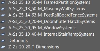
Layer Naming:
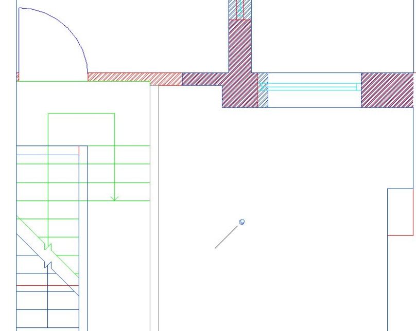
This one was also pretty simple as I have opted to also follow the BS1192 container naming for my AutoCAD layers. Using NBS‘ Uniclass 2015 search tool, I identified the appropriate system classifications for the layers I needed to survey my: Walls, Doors, Stairs, & Windows and dimensions. Note: Please ignore the bright colours in the CAD files, they are a visual aid more than anything else.
Symbology:
Referring to my copy of BS8541-2, I made sure that any symbols I used were included within. In this file I had a number of symbols which included: Architectural ticks for dimensions, and 2 ceiling height symbols (one for ceiling height, and one relative to FFL). In addition, I also needed to use symbols to represent doors, windows, stairs and walls; all of which are included within BS8541-2, even the brick hatch that I used is specified within. Using clear symbology based on an agreed standard when drafting is key, as without a clear message on drawings, disaster can occur.
Origin Point & Tolerances:
Finally, by following the origin point I had set out in by BIM Execution Plan, I was able to ensure that my files align providing a coordinated set of survey data. In fact to make sure that my survey’s aligned I imported both of them into Revit to compare. UnSurprisingly, both files closely aligned, after taking a few extra check dimensions and then resigning to the fact that buildings are not straight. I tweaked a few final dimensions within tolerance and ended up with two coordinated survey files that line up perfectly when imported based on their origin points.
There you have it, by planning how I need to undertake the work, I was able to efficiently produce coordinated survey data in a usable format, ready to be used to produce my 3D graphical models. However, as I haven’t produced floor plan PDF deliverable, so I won’t call this Plain Language Question complete just yet:
Model Generation:
2.1 What existing information is available?
2.2 Is there sufficient information to produce a BEP?
2.3 What is the layout of the house?
2.4 What assets are contained within?
2.5 What asset information can be linked to the graphical model?
Now that I have my 2D survey data, it’s time to finally do some 3D modelling…
Note: If you have any comments or opinions regarding my survey files, please let me know either on twitter, or commenting below.

Hey Dan,
Your layer names need some fixing (in fact to get rid of some of the underscores) the hyphen should be used to split fields so it should be:
A-Ss_25_10_30-M-FramedPartitionSystem i.e. the underscore between the “M” and description and your dimension level has one between the classification and the “T” which should also be a hyphen.
LikeLike
Hi Dan,
Thank you.
Your point about my Dimension layer is correct (that’s what I get for rushing at 1am to finish this).
However, BS1192 states under 5.1 that description should be prefixed with an Underscore and gives an example in Table 4; so I stand by my Layer naming but will quickly be updating the files to resolve the Dimension layer text. Thank you for paying attention to what I’ve done, much appreciated!
LikeLike
ps who validated your survey? 🙂
LikeLike
I did, check my BEP 😉
LikeLike
[…] PLQ2.3 – Survey […]
LikeLike